
Search Man property records
A Man address is only one label among road, hollow, community, E-911, and mailing names. The town does not handle ownership or assessment. Begin with a county parcel account, then use the Clerk for a recorded deed. Go to the Town of Man for municipal permits or zoning records.
- Normalize the road name and any local hollow or community wording.
- Use Logan County's assessor form to find the account by Parcel Address, owner, or parcel identifier.
- Copy the account, full District/Map/Parcel, legal description, and deed reference.
- Select the land in WV Property Viewer and compare E-911 and Community fields.
- Ask the Town of Man about permits, zoning, streets, or annexation material.
The county-wide assessor and deed steps are described on the Logan County search page. This city page stays focused on how a Man address becomes a county parcel, a town question, and a historical land reference.
Man town records and county custodians
Logan County is the custodian for assessment accounts, parcel mapping, recorded deeds, plats, and liens. Sheriff tax records and circuit files sit there too. The Town of Man is not the custodian. The town handles local permits, zoning, streets, signs, and municipal actions. Logan County provides no separate recorder or assessor for Man. Keep the permit question separate from the county ownership search.
Logan County Clerk and Assessor
300 Stratton Street
Logan, WV 25601
Clerk 304-792-8600
Assessor 304-792-8520
Town of Man
Municipal permit and zoning questions
Contact the town office directly
No public search portal verified
Ask the town whether permits are held there or handled through another office. The county publishes no online permit interface for Man. That is an access gap, not proof that no permit exists.
Man hollow labels and parcel clues
A Man address may use a road number or hollow. It may use a community name or post office. Some rely on an E-911 designation. These labels can differ across a tax bill, assessor card, map, and deed. Normalize the house number and road suffix. Then keep the original spelling and every alternate community label. An out-of-county mailing address does not put the property outside Logan County.
WV Property Viewer can display a selected parcel's physical address. It also shows the E-911 label and community. Owner, building details, and values appear there too. So do delinquent status, flood context, and neighboring parcels. Those fields help translate a local road description into an assessor account. They do not replace the legal description or prove a boundary.
Man property records get easier with one habit. Keep the E-911 and community names beside the account number. If the address fails, switch to Account #, District/Map/Parcel, Deed Book/Page, or the legal description. Avoid picking the nearest shape by appearance alone.
Use the Logan County Man account fields
The public form shows four Map/Parcel positions. The county's exact numbering scheme is not documented. Keep every displayed part. Ask the assessor about any uncertain component. An account may name an LLC, trust, estate, or fiduciary. Compare its deed reference and location before deciding it is the parcel you want.
If the selected Man shape does not match the bill or deed, check the legal description and adjoining tract clues before accepting it. Valley roads and community names can sit beside a different tax parcel than expected. Entity names and estate roles also appear on Man tax accounts. Treat them as ownership labels, not a resident list. Verify each against the deed reference.
Man plats and subdivision names remain unverified
No published index identifies three or more named Man subdivisions or a town plat. Resist inventing neighborhood names from local speech or a real-estate listing. Ask the County Clerk for recorded plats. Ask the Town of Man for planning or municipal files. Exact subdivision names, lot ranges, book and page numbers, and eras should come from those records.
| Land clue | What is known | Next record |
|---|---|---|
| Named Man subdivision | Not verified in inspected official sources | Clerk plat index and town records |
| Valley road lot | Current mailing label may be broad | Parcel, E-911, legal description |
| Historic tract | May use creek, survey, or neighbor | Deed, land book, survey reel |
The clerk's fee page lists plat maps at $11, but confirm the exact current charge and reference before ordering. A recorded drawing may reveal roads, lots, and rights of way, while a tax map reflects present parcel mapping. A licensed surveyor is needed for a line on the ground.
Man municipal permit records have no verified portal
Man property records split into two access channels. Logan County holds title and assessment material, and the town keeps local actions. The town publishes no public permit or zoning search portal. Search fields, PDF forms, case numbers, fees, and result limits are unknown. Contact the town directly about building, zoning, sign, street, and annexation records. Give the road address, parcel or account number, work type, and approximate date. Then ask whether the town or another office holds the record.
If permits exist, request the permit number, issue date, applicant, scope, inspection status, and copy fee. These are items to ask for, not guaranteed database fields. An assessor card can describe improvements, but it cannot prove a municipal permit was granted. Tag each response with its custodian and date. That keeps the county and town answers separate.
Follow Man's older valley land history
Older Man parcels often predate modern road numbers. The WVU Logan finding aid helps here. Grantor indexes sit on reels LOG 1-4. Grantee indexes sit on LOG 5-8, and deed books sit on LOG 9-19. Surveyor records occupy LOG 177-179 and LOG 202, with land books on LOG 181-188. Contracts, leases, commissioner records, and wills fill other reel groups. A tract may be identified by creek, survey, coal-company land, acreage, or a neighbor. It may not carry a street label at all.
Start from the current account and the latest deed book and page. Then work backward through the grantor and grantee indexes. Record every legal description, acreage, and adjoining name you find. A historic map or land-book entry can tie a valley tract to a later road label. Even so, it stays a separate source from the modern tax map. Man property records may still carry an older tract description. The assessor may show an E-911 address at the same time. Keep both versions so the history survives the change in addressing.
Reach Man deeds before the Cott range
The County Clerk reports that Cott's online convenience route covers land deeds, trust deeds, and liens. It reaches filings from 1988 to the present. Earlier Man chains run through county books, microfilm, WVU, and State Archives material. The State Archives holds typed Logan deeds from 1836-1894 plus deed-index material through 1935. These are archival holdings. They do not promise that every image is digitized.
For each transfer, capture the parties, recording reference, legal description, and date. Search the grantee as the next prior owner. Then find that same party as grantor in the earlier index. An estate or company can change the name. Search the fiduciary or entity exactly as written. Request specific reels or book ranges rather than a broad sweep.
Remember what an online cutoff means. It limits one convenience system. It does not erase a parcel's record before 1988. It never explains an apparent gap by itself.
Map Man neighbors along valley roads
Select the subject parcel in WV Property Viewer first. Then note the neighboring map shapes and any visible parcel identifiers. The viewer offers no buffer tool and no automatic adjacent-parcel function. Click nearby shapes one at a time, and use the Logan assessor Map/Parcel or Account # to open each tax card. Two lots can look joined at low zoom while a road, stream, or narrow right of way divides them.
The map translates a valley-road location into nearby parcels. It cannot prove that anyone occupies a neighboring property. Owner mailing addresses may sit far from Man. When a shared line matters to a purchase, fence, or access question, rely on the legal description, plat, and survey instead.
Use Copy Link or Download KMZ to preserve a current parcel view. Treat that output as a working locator. It is not an official boundary.
Man value and municipal boundary limits
Man's 2020 Census population was 772. That figure is a historical count, not a current estimate. The town publishes no Man-specific value-trend series, ZIP coverage list, annexation chronology, boundary-edge enclave list, or municipal permit portal. For a specific parcel, use the county assessor's values and current tax class rather than substituting an online estimate.
West Virginia class rules turn on municipal boundaries. Class II covers owner-occupied residential property and owner-used farms. Class IV is comparable taxable property inside a municipality, and Class III sits outside. Never decide the class from the postal town or ZIP alone. Compare the current place polygon and the account. If the classification looks wrong, ask the assessor.
The Census incorporated-place table supplies the population roster, and its image appears below.
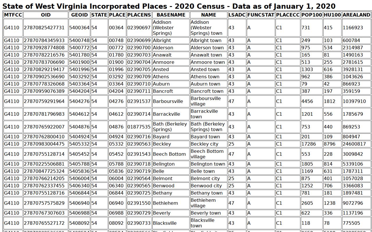
Treat the population figure as historical context only. For ownership, value, or boundary facts, go back to the parcel, deed, and official municipal record.
Use Man records for lawful property research
Man property records support due diligence, local history, tax review, and boundary questions. Know their limits. An owner name is not proof of residence. A GIS line is not a survey. A tax class is not a sale price. A missing web portal does not mean the town has no file. Keep each record tied to its source, date, parcel, and purpose.
Respect personal safety. Do not use parcel maps, owner names, or address labels to stalk, threaten, harass, trespass, or target anyone. Verify important facts with the Logan County or town custodian.
Match the route to the question. Older title calls for land-book and deed references. Town work calls for the Town of Man. A line on the ground calls for a licensed surveyor. Those separate routes make a Man property search far more reliable than a guess from a label.