
How to find a Logan County property owner
Start at the assessor. That office connects each parcel to a tax-account Owner Name, which makes it the fastest way to turn an address into a name. Then go to the clerk, whose deed records hold the instrument that actually transferred the interest. A GIS map helps confirm both records describe the same land. This route answers who owns the parcel today. It is not a title search.
- Enter the street or road in Parcel Address on the Logan County assessor form.
- If that misses, search Owner Name as LAST NAME FIRST NAME with no comma, or use a bill's account and District/Map/Parcel.
- Copy the physical or situs address, mailing address, legal description, owner field, and deed book/page from the account.
- Search the clerk's land-record portal for the newest deed or ask the clerk for the instrument.
- Compare the deed's grantee and legal description with the tax card and map before treating them as a match.
Logan County keeps the deed, the tax roll, and the GIS map as separate records. A reliable match comes from shared identifiers, not from spotting the same surname on two screens. For today's roll entry, the Logan County current owner page walks through the steps, while the deed chain has its own method for prior owners.
Where Logan County ownership appears
Ownership clues live in several offices. Each source has its own date and purpose. The assessor names the tax-account owner. The clerk records transfers and liens. The GIS viewer places a selected parcel on a map. The most useful result is the one that carries a reference into the next record, whether an account number, map/parcel, deed book and page, or legal description.
| Source | What it contributes | How current it can be |
|---|---|---|
| Logan County assessor | Owner Name and tax-account parcel details | Annual roll work; not a daily transfer feed |
| County Clerk / Cott | Recorded deed, parties, instrument, and reference | Recording date is tied to the filed instrument |
| WV Property Viewer | Selected parcel, owner card, E-911, community, and map | Dynamic data; verify with source office |
| Probate file | Estate authority and a possible transfer bridge | Request the relevant clerk file |
For deed, trust-deed, and lien searches filed from 1988 forward, the county clerk directs researchers to Cott. A portal record can point you to the instrument, though the portal does not publish its full field list or image fees. When the latest transfer is older or missing there, the clerk's counter and historical reels are the next access route.
Use the Logan County address and name keys
Start with the full or partial Parcel Address. If a rural road or hollow name fails, try the community wording. You can also try a number from a prior tax bill. The form also accepts Account #, District, Map/Parcel, Property Type, Legal Description, and Deed Book/Page. Combine them in any way you like. You do not need to fill every box. Logan County shows four separate map/parcel inputs, so copy each part exactly.
Owner Name has the portal's biggest quirk: surname first, given name second, with no comma. If a familiar name returns nothing, try the legal name shown on a deed. For a trust, LLC, estate, or fiduciary, search the entity or representative exactly as the recorded document names it. The tax-card owner can be a legal entity. A person's name may not be the right key at all.
A failed query does not prove an owner or parcel is missing. Partial addresses, spelling variants, and dropdown choices all affect results. Use a second independent key when you can. Then compare the card's legal description with the clerk's instrument.
Read the Logan County Owner Name field
The Owner Name field shows who the tax account lists. It is a strong way to locate a property account, but it is not a certified deed or title commitment. Once you find it, record the accompanying account, map/parcel, class, mailing and situs addresses, value fields, and Deed Book/Page. A similar name on another account is not the same property.
The Logan County GIS card adds Property Owner, physical address, E-911 address, community, building information, cost and appraised values, delinquent status, flood information, and an assessment-report link. That panel helps test whether an address belongs to the selected parcel. Still, the card is a dynamic map record, not a recorded conveyance.
The assessor's public search form displays the account fields that start this lookup, including the address, name, and map/parcel keys a visitor can use.
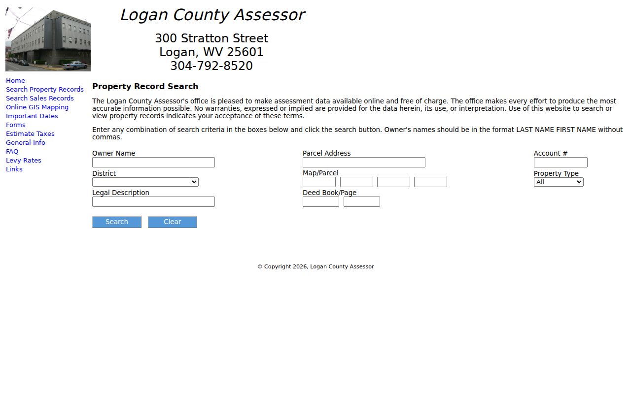
The Owner Name result should lead you back to the deed record. That is where the question of who owns the land now finds its answer.
Confirm a Logan County owner with the deed
Open the clerk's land-record index once an account search gives you a book and page or a likely owner of record. Read the instrument type carefully. The grantor conveys an interest; the grantee receives it. Every entry also lists the legal description and the recording reference you will need for a copy. Not every instrument transfers land, though. A deed of trust, release, lien, lis pendens, or trustee report of sale is not a deed of conveyance, so identify the document before drawing a conclusion.
Then match the deed's description to the tax parcel. An older instrument may omit the street address entirely. Acreage, tract, lot or addition, a river or creek, the survey, and named adjoining owners can bridge the gap between the two records. If the most recent instrument falls outside the online range, the clerk can run a book, reel, or counter search to confirm it.
The assessor's Owner Name can lag a closing while county books are prepared. Use the recording date instead. That date marks the paper trail. Treat a mismatch as a prompt to ask the assessor or clerk rather than proof that one system is wrong.
Separate Logan County mailing and situs addresses
A mailing address shows where tax notices go. The situs address is different. It describes where the parcel actually sits. An E-911 address helps responders locate a site, and a Community field may carry a wider local label. In Logan County's valley and hollow geography, all four labels can differ. An out-of-county mailing address does not move the land out of Logan County.
Compare before you conclude anything. Check the selected map location, the legal description, and the District/Map/Parcel together. A ZIP code or postal town cannot settle whether land lies inside Logan, West Logan, Chapmanville, Man, or an unincorporated community. Current incorporated-place geometry is the better boundary clue.
Handle names and mailing addresses with care. The state Address Confidentiality Program gives qualifying survivors a substitute address and mail forwarding for government transactions. It does not erase the records. Keep private contact details out of public posts when the property question can be resolved through the office.
Check a Logan parcel on the map
WV Property Viewer is the next step after the owner and account search. Select the parcel. Read its owner and physical address, check the E-911 and community labels, and compare the assessment-report link with the assessor card. Highlight ON, Copy Link, and Download KMZ all help. The flood layer offers context only. Neither it nor an adjacent parcel shape is a survey line or deed proof.
Logan County's address labels can name a city or community without settling municipal boundaries. A map polygon helps separate a Logan city parcel from West Logan or a spot near the county line. The deed's legal description still ties map to instrument.
Use the state parcel viewer as a locator. Follow the adjacent-parcel method. A neighbor parcel may be part of the question, and the owner card alone does not show who lives there.
When Logan County ownership comes through an estate
A deceased owner's name can stay on an assessor account while probate and land instruments catch up. The County Clerk holds the relevant records. That office handles wills, estates, guardianships, notices to heirs, and related files. A death-transfer search may touch several names. The decedent, an executor or administrator, heirs, a probate file, and a later deed can all play a part, and the recorded transfer plus the authority in the probate file explains why names differ across records.
The WVU Logan finding aid lists Will Books 8 and 9 plus LOG 188, “Land Book 1927, Index to Wills A-Z,” along with appraisement and sale books. Ask the clerk or archive for the exact volume or reel. Never assume a probate file is fully searchable online. The clerk's Cott coverage statement covers deeds, trust deeds, and liens from 1988 forward. It promises nothing about every estate file.
An obituary is historical context only. It can suggest a family link or a date. It is not title evidence. Keep Social Security numbers and protected medical details out of notes and public messages, and let the deed and probate records carry the proof.
What a Logan County owner lookup cannot prove
An owner lookup has firm limits. It does not show who lives there. It also cannot confirm a clear title, a paid lien, or an exact parcel line on the ground. Each record answers one bounded question. For a consequential ownership or boundary issue, a title company, attorney, surveyor, or records custodian may be needed.
Lawful purpose. Logan County owner information is for legitimate property research, family history, civic review, and due diligence. Do not use it to stalk, threaten, harass, trespass, or expose a person at risk.
For deeds and the historical chain, move to the clerk's indexes and older books rather than a single result card. Note the exact parcel. Note the source date too. That written trail lets another researcher repeat the search without publishing personal details.