
Run a Logan County property search
Treat a Logan County property search as a chain: address, then parcel account, then deed. Start in the assessor's Parcel Address box. That works when you know the street. It also works with a road name. The full address may return nothing. Then try a partial form. The form does not promise a street-wide list. Once a card opens, copy the account number, District, Map/Parcel, legal description, and Deed Book/Page. Those keys carry you to the clerk's record without leaning on a postal label.
The public assessor form is free and leaves most fields optional. An address may be old. A road may go by a hollow or community name. The situs field may not match the way a bill is mailed. So treat the first result as a lead only. Check that the legal description, map number, and physical location all fit the property you meant. Then compare values or call the clerk.
- Search Parcel Address with the known road name, then try a shorter street or community variant if needed.
- If the address misses, enter Owner Name as LAST NAME FIRST NAME without a comma.
- Use Account #, District plus Map/Parcel, Legal Description, or Deed Book/Page when a prior bill or deed gives you a stronger key.
- Open the assessment result and copy the account, owner, situs, mailing address, class, value, and deed reference fields.
- Use Cott or the clerk counter to check the latest recorded transfer, then use GIS for parcel location.
Keep the first pass mechanical. Logan County carries many rural road and hollow labels. Conversation can rename a place, so the parcel key holds steadier than a spoken description of the location.
Enter Logan County owner names correctly
The assessor asks for owner names in one specific order: surname first, given name second, no comma. "SMITH JOHN" fits. "Smith, John" does not. Middle initials, estates, trusts, and companies may need the spelling shown on a deed or tax card. Work through the variants carefully. Write down the exact spelling that returned a result.
A name match is not a unique person identifier. Two people can share a name. One person can appear as an individual, a spouse pair, an LLC, or a fiduciary. The record tells you which. Before treating a hit as the property you want, compare the account, physical address, legal description, district, and deed reference. A name alone should never serve to contact someone or to guess who lives at an address.
For an LLC or trust, search the exact grantee name from the recorded deed. The assessor's Owner Name field may carry the tax-account owner, while the deed names the party in that instrument. If title passed through an estate, search the decedent and the executor or administrator alike. The latest recorded document checks a current tax-roll name.
Logan County's visible assessor search fields
The property form offers more than an address and a person name. It accepts any mix of criteria, which helps when one identifier runs thin. Not every dropdown option appears in the published listing. Exact matching behavior goes unstated. Treat the field labels as an index of possible keys. They are not a promise of a uniform result. Every spelling, range, or partial value may not return the same outcome.
| Field label | Input type | How to use it | Known limit |
|---|---|---|---|
| Owner Name | Text | Surname, then first name | No comma; match rules are not stated |
| Parcel Address | Text | Enter street or address text | Street-list behavior is not promised |
| Account # | Text | Use a bill or prior card | Format is not stated |
| District | Dropdown | Select the district if known | Live options were not captured |
| Map/Parcel | Four text positions | Copy each displayed part | Exact format is not documented |
| Property Type | Dropdown | Narrow by the account type | Options were not captured |
| Legal Description | Text | Try lot, tract, or deed wording | Matching rules are not stated |
| Deed Book/Page | Paired fields | Enter both parts of a reference | Retain the clerk's exact citation |
The Logan assessor's own property search form holds these controls. The image shows the field arrangement. Check the live form for current labels and dropdown choices.
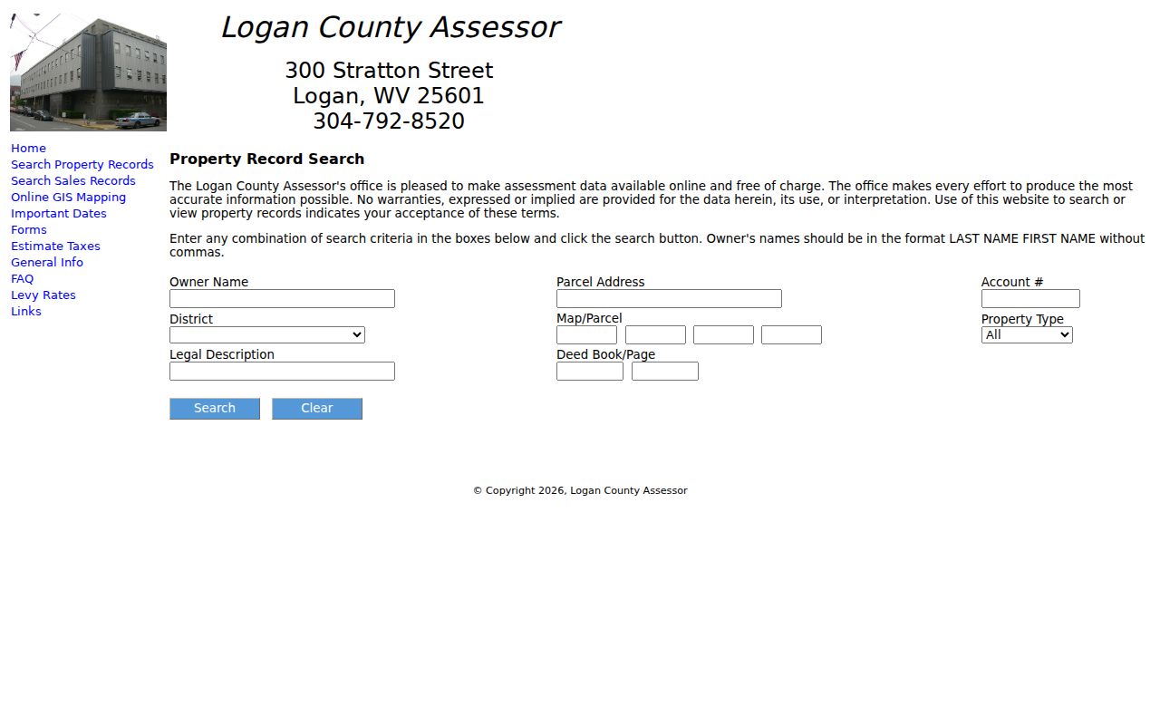
Use the four map/parcel boxes as displayed. When a prefix looks odd or a zero seems missing, ask the assessor rather than guessing at the identifier.
Recover a Logan parcel when an address misses
Address text is a starting point, not a parcel identifier. Logan County roads go by towns, wider communities, hollows, coal-camp names, and E-911 labels. A mailing city can sit outside the incorporated place you expect. Try a shorter road name or the wording from a tax bill. Keep the first spelling you searched. That way you know which route worked.
When an address falls short, climb a ladder of stronger keys. Start with Owner Name in the required format. Next comes Account # from a bill. Then District and Map/Parcel, Legal Description, and finally Deed Book/Page. An older deed can carry a land description even without a street number. Copy punctuation, initials, lot names, creek or river references, and acreage. A legal description may predate the road name.
A road label may have changed. An address may be missing altogether. In either case, ask the assessor whether a map/parcel or account can locate the card. The public form states no parcel numbering rules. Four visible inputs suggest a multi-part key. Never infer district prefixes or tract conventions from a partial number. The clerk and assessor can identify the needed format from a known record.
What a Logan County assessment card returns
An assessment card in Logan County is really a tax account. It ties an owner of record to one parcel. Expect fields for the property class, improvement details, appraised and cost values, and a deed reference. Sales or tax indicators may appear too, though the live card decides what shows.
The statewide GIS map supplies its own selected-parcel report. That report adds a sample inventory: Property Owner, physical and E-911 addresses, community, building information, cost and appraised values, delinquent status, flood information, and a report link.
Keep the location fields distinct. A mailing address tells the assessor where tax mail goes. A situs address points to the parcel itself. E-911 helps responders and map users find a site. Community reflects a local label. None of these is a legal description. Compare all of them against the selected parcel before tying a name to a property.
The assessor's landing page gathers the free search, sales search, GIS, forms, dates, tax estimate, FAQ, and levy resources. It works well as an overview. For a single account, the search form is the better entry point, and the Logan County Assessor landing page carries all of these tools.
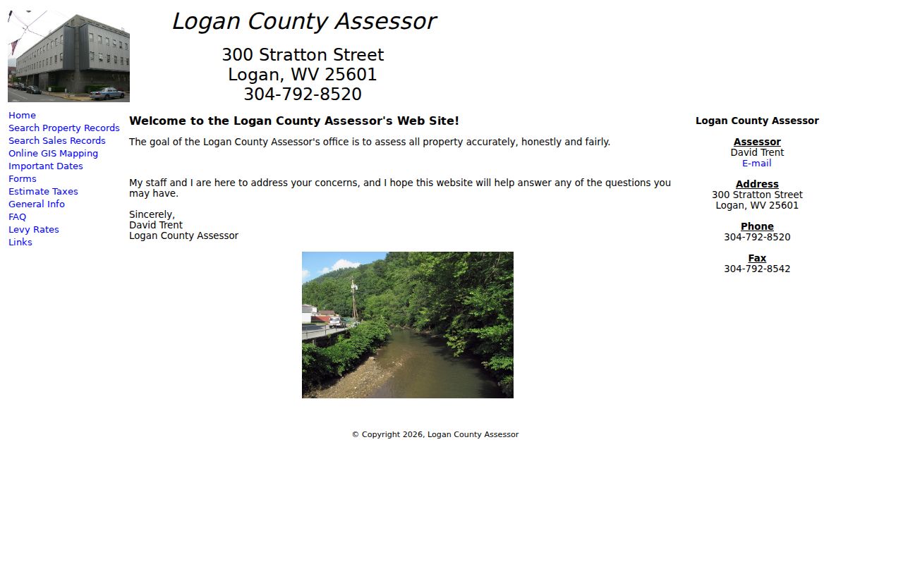
Move between tools through the landing page. Once a result card appears, hold onto the account number and the map/parcel values it displays.
Keep Logan County sales search separate
The assessor keeps a separate sales search. Its filters span a start and end date, minimum and maximum price, square-footage range, acreage range, Property Type, Sale Qualification, and Sale Type. This tool reviews recorded transfer data as a group. It is not a deed index or an appraisal. The dropdown options live in the form itself, so avoid assigning meaning to a particular choice before the live form loads.
For comparable-sales questions, narrow the date range and property type first. Then note acreage and area differences before reading any price as a guide. A sale may be nonqualified. It may simply differ from the subject property. Recorded consideration proves a transaction happened. It is not automatically the assessor's true and actual value, nor the price a future buyer would pay.
Logan County Sales Search is a distinct official form with those filters. Save the sale date and property identifiers you need. A promising result can then be traced back through the clerk's recorded instrument.
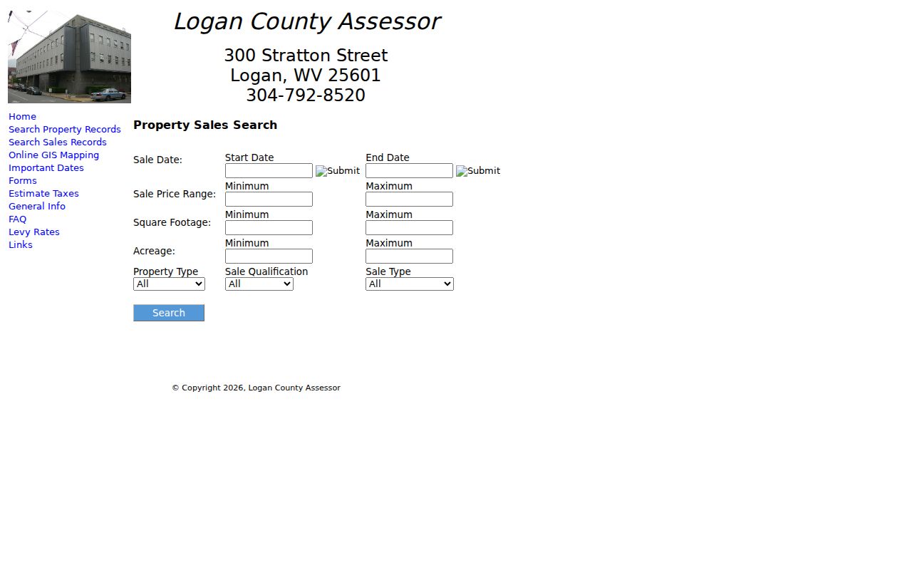
The sales tool sits apart from the assessment search. Use it for context around recorded transactions, not as a list of current asking prices.
Copy Logan County parcel numbers exactly
The assessor form shows a District field and four Map/Parcel input positions. Treat the full value as a sequence of parts. Keep leading zeroes, separators, and district labels. A shortened parcel number can pull a different account or return nothing at all. That risk grows when the number is copied by eye from a map.
When a prior tax bill or deed supplies a parcel key, transcribe it before opening another portal. Store the account number beside the full displayed map/parcel. If two systems render the parts differently, ask the assessor which input takes each segment. A partial entry that fails does not make the map label wrong.
Deed Book/Page offers another route into the account. The assessor accepts them as paired fields. An old instrument citation can recover a property whose modern street address is unclear. That fallback is unusually useful in Logan County. Still, confirm the recorded document on the clerk's side.
Move from a Logan County account to a deed
Once the assessor flags a likely account, carry its deed book and page to the County Clerk's Cott portal. The clerk's online convenience link covers deeds, trust deeds, and liens filed from 1988 to present. The clerk publishes no list of the portal's field set, result limits, image fees, or oldest scanned year. A record missing online may still sit in an earlier book.
Write down every field the result exposes. Note the grantor, grantee, instrument type, execution and recording dates, legal description, and book/page. The grantor conveys the interest. The grantee receives it. A deed recorded after the assessor book was prepared can make the clerk's date newer than the Owner Name card. For a recent sale, read the instrument and ask whether the roll has been updated. Only then call the tax card current.
The two offices answer different questions. The assessor locates an account and displays tax data. The clerk holds the recorded instrument itself. The deed-records section explains the 1988 online boundary and the historic index route.
Use Logan County GIS to check a result
The statewide WV Property Viewer supplies the map half of the check. Pull up the parcel there after a property search in the assessor system. Compare the owner of record, the physical address, the E-911 address, community, building information, cost and appraised values, and delinquent status against the assessor card. Check the flood data there too. The viewer also gives you Highlight ON, Copy Link, and Download KMZ. Save the copied parcel link. That way anyone can reopen the same map view later.
A map earns its keep when two parcels carry the same road label. It can also separate an in-town lot from a site in a nearby community. Still, it is not a legal boundary. Flood Zone is a layer, not an ownership line. A parcel outline is never a survey. Open the linked assessment report to check account details. Then turn to the clerk's deed records for the legal description and transfer history.
Logan County terrain can make a correct card look unfamiliar. Address labels shift from road names to hollow names. Compare the E-911 and community fields against what you know. Then lean on the account number and map/parcel number to lock the result down. For the map-reading procedure itself, see the Logan County parcel-maps page.
Limits of a Logan County property search
Any search result is only a lead. It cannot prove that no later deed transfer exists. It cannot confirm someone lives on the parcel, that the tax bill is paid, or that a map line marks the true ground boundary. The Owner Name field comes from the tax roll. A deed is a recorded instrument. A court docket reveals litigation. Only a surveyor settles a boundary question. Match each property records question to the source built to answer it.
Read the result in context. Use Logan County records for property research and due diligence. Do not use addresses or owner names to stalk, threaten, harass, or expose protected personal information. Confirm important results with the office that keeps the record.
Some names and account numbers deserve extra care. Keep them off public posts. West Virginia's Address Confidentiality Program gives qualifying survivors a substitute mailing address. It also provides mail forwarding for government transactions. The program cannot erase a deed or automatically remove all land records. For a particular Logan County record, contact the custodian directly. The same goes for a protected-information rule, so avoid sharing personal data widely.